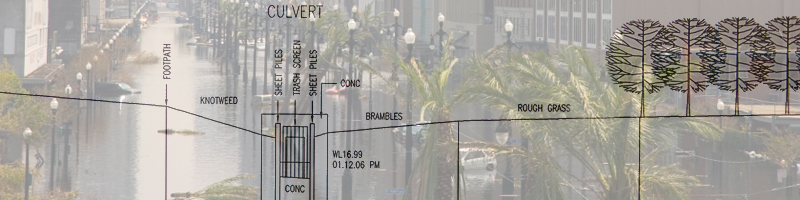
River & Floodplain Surveys
Clients appreciate the benefit of having a survey carried out by experienced Chartered Land Surveyors, regulated by RICS. It allows you to:
» work with confidence
» reduce the risk of delays in your project
» understand and explain graphically to your clients and colleagues
We carry out river, floodplain and beach surveys to the latest Environment Agency specification (or your own).
» we are fully conversant with the demands of the specification
» surveys are tied-in to OS grid and levels
» we carry out least-squares network adjustments of post-processed GPS observations
» we provide surveys of sections, structures, beach profiles and ground models
View samples of river and floodplain surveys.
Over 80% of our work is repeat business. Why do these clients keep coming back? The client gets what they need:
The Process
Submit tender documents by post, fax or email
or
Call us to discuss briefly:
» Where the job is?
» What are the extents of the job?
» What the purpose of the survey is?
We will then get back to you with a price, a proposal and time-scale. Usually we make a site-visit to assist us in this process. Some returning customers choose to email the details and then may follow up with a call.
We receive an instruction to proceed. We carry out the survey in a professional manner and present it as appropriate.
How can it be so straightforward? We are Chartered Land Surveyors, regulated by RICS, with Professional Indemnity insurance. We have 25 staff, many with over 30 years experience in the UK Survey industry.
Contact us today to see how can help you.
