
Portfolio

Topographic Surveys
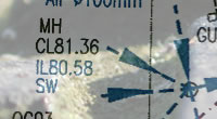
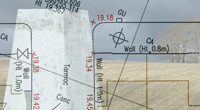
>> A Topographic Plan shows both natural and man-made features with level information, often related to Ordnance Survey National Grid and levels.
>> Drawing office quality systems ensure high quality, easy to use, drawings with a consistent appearance from one project to the next.
>> Surface types, Fence types and heights as well as other features such as tree species may be shown.
>> Surveys can be configured to open in Google Earth as well as in AutoCAD and MicroStation.
>> Sample 1 | Sample 2 | Sample 3 | Sample 4 | Sample 5 | Sample 6
Deformation & Monitoring Surveys
>> Current surveyed and compared against the design shape to determine the extent of deviation.
>> Current shape accurately surveyed and compared against the previous shape survey to determine deviation since the last survey.
>> Condition survey with high definition film photography looking at individual features. >> Sample 1 | Sample 2 | Sample 3

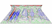
Contours
>> Quickly get a feel for the lie of the land by looking at a drawing showing contours.
>> An appropriate contour interval can help quickly identify lumps and bumps in as-built surveys of car parks, building slabs.
>> Contours showing deviations from a design surface can be created and set out, typically for earthworks reworking and slab planning/grinding.
>> Contours are also used in Ground modeling and 3D visualisations.
>> Sample 1
Measured Building Surveys
>> Accurate floor plans, roof plans, elevations and sections can be created for use in your Project, reducing risk and saving both time and money.
>> Digital photography can be related to the Survey drawings to assist interpretation.
Floor Plans
>> Precisely surveyed Floor Plans are used in many re-development projects.
>> Floor Plans can be complemented with building sections, elevations, roof plans, service tracing and photography.
>> A Floor Plan can form the basis for an asset management survey, even if the final deliverable is a database rather than a drawing.
>> Floor Plans can be overlaid onto Topographic, Contour surveys and Utility surveys.
>> Sample 1 | Sample 2 | Sample 3 | Sample 4 | Sample 5 | Sample 6 | Sample 7
>> Sample 8 | Sample 9
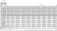
Elevations
>> Elevations and Sections of existing buildings have a role in both new development and re-development projects.
>> Planning, design and re-instatement works are all aided by having accurate Elevation and Section drawings, often of neighbouring buildings.
>> Time and cost savings in Heritage recording are achieved by combining digital photography with precise Elevation and Section surveys.
>> Sample 1 | Sample 2 | Sample 3 | Sample 4 | Sample 5 | Sample 6 | Sample 7
>> Sample 8 | Sample 9

Sections
>> Sample 1 | Sample 2 | Sample 3 | Sample 4 | Sample 5 | Sample 6 | Sample 7
>> Sample 8 | Sample 9 | Sample 10 | Sample 11
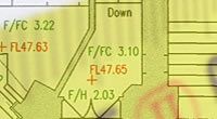
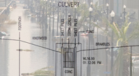
Underground Utility Services and Drainage
>> Information is added to Topographic Surveys and presented clearly, precisely and consistently.
>> Reduce the amount of digging (and waste) when locating utilities on site.
>> Costly Project delays can be reduced by having the information available up-front for use in Planning, Design and Project Management.
>> The risks and costs of accidents related to Underground Services and Drainage are reduced by having information available at the start.
>> Sample 1 | Sample 2
Ordnance Survey Background maps and Google Earth
>> Have your survey overlaid on OS background mapping and/or Google Earth to check your boundaries or Registered Title.
>> Overlay your design onto an OS related Survey to help with Planning and Design.
>> Overlay your design onto a Google Earth related Survey to help with Planning and Design.
>> Use an OS related survey as a basis for 3D-Visualisation work.
>> Sample 1

NIA, GIA (Net Internal Areas and Gross Internal Areas)
>> NIA and GIA plans are produced using the current RICS Code of Measuring Practice.
>> Consistency, precision and clarity of presentation are key elements in these drawings.
>> Sample 1 | Sample 2 |Sample 3

Lease Plans and Title Plans
>> Plans are produced to meet the required standards of both the Legal Profession and HMLR (Her Majesty's Land Registry).
>> Plans for Sub-divisions of plots and buildings are drawn.
>> Different Plans for different floors within a building are often produced, accurately representing the relationships between floors.
>> Sample 1

Boundary Surveys, Boundary Determination and Boundary Dispute Resolution.
>> Boundary features are surveyed and related to the Registered Title and other documentation. This is then presented on the drawing for comparison.
>> Ideally a Boundary Survey is done before a development is designed but it can also be done later should a Boundary issue comes to light.
>> One of our Chartered Land Surveyors can usually form an opinion as to the most likely position of the Legal Boundary which he can then set out.
>> An agreed Determined Boundary can be established between neighbours and presented to HMLR without involving the legal Profession.
River Surveys, Floodplain and Coastal Surveys
>> River, floodplain and beach surveys are carried to the latest Environment Agency specification (or your own).
>> Long-sections, cross-sections, structural surveys, floodplain surveys, beach profiles and ground models can be produced.
>> Using the SmartNet GPS service we are able to provide cost-effective OS level information to any project, including insurance claims.
>> Again using the SmartNet GPS service we have surveyed river bank levels with related photography for use in GIS and viewing in Google Earth.
>> Sample 1

Right to Light Surveys
>> Right to light surveys can be supplied as 3D CAD drawings such as AutoCAD or Google Sketchup.
>> Digital Photography can be draped over the survey to assist interpretation.
Contact us for more information.
